Wednesday, January 26, 2011

Fitzgerald Bay to Port, then Point Gibbon - running out of superlatives!

Fitzgerald Bay – Whyalla – Port Gibbon
Tuesday, Jan. 25th
Our 1st stop was the Whyalla Maritime Museum and it was a great way to start the day. The $10 entry was great value as the museum is home to the ‘Whyalla’, the 1st ship to be built in the shipyards in the ‘40s. After touring the museum we had a guided tour of this corvette/minesweeper which saw service from 1941 to 1946, then was sold to Victoria where one of her jobs was in the blasting of the Port Phillip heads.

The Whyalla Maritime Museum

The smelter
Whyalla is a town something like Gladstone but on a smaller industrial scale.  The buildings, paved areas, roofs etc are all red and the smelter generates lots of red dust so this fits in well. Wide streets, incredibly clean, as are most SA towns it seems (no plastic bags offered in shops and bottle deposits paid) but not much here. A quick swim at the foreshore and a solar-heated shower to rinse off, then off to Hummock Hill to look down over the town and the water. 
From Whyalla we drove past Iron Knob, the flattened hill from which the ore has been extracted for many years and is still being mined, to Cowell, the home of the oyster farms – although a number of Eyre Peninsula towns claim this as their title. Cowell is another of the fishing towns along the gulf, with a long jetty, a big pub and not much else. Graeme had a quick lesson in oyster shucking and we bought a dozen unopened oysters for my dinner, some sourdough bread and a bottle of wine!  

Oysters at last!

We then drove on to Port Gibbon, our free camping site for the evening. It was a ‘first’ in many ways – the locals had taken ownership of this site and had set up rules and regulations about the way the vehicles should be parked on their bit of red dirt, some areas were roped off, there were drop toilets with signed stones along the shelves, sea urchins threaded on string and an amazing assortment of bits and pieces. The area looked a bit like a dump, with an assortment of vehicles, including an ancient blue bus, campsites with clothing spread around, people sleeping in cars etc. Definitely not a room with a view! However, the sea was just a quick walk down some steps and the locals indicated that the fishing was good, so we settled in for the night although the wind was too strong for us to put up the awning.
Port Gibbon – Colwell – Point Gibbon
Wed. Jan 26th

The national flags were flying as we headed off to Colwell to try our luck with crabbing – we bought a net in Whyalla so that we could take part in this SA summer ritual. We’re almost able to accept that the wind will be with us wherever we travel along these SA coasts. The bikers were in town and their gleaming Harleys and others were parked along the front of the pub. Others were spending Australia Day playing cricket in the park on the foreshore.
Graeme baited the crab net with a whole mullet and we launched the net, then he set up his fishing rod and I walked along the short mangrove boardwalk while he waited. Alas, one small crab and no mullet. Something big and strong had managed to remove the whole fish. This set up a challenge for GVS as he is determined to find a way of securing the 2nd mullet to the net so that even a tsunami could not remove the fish! We’ll see when we next try our luck.
We returned towards Port Gibbon but decided to take the track up to Point Gibbon – what a difference a name makes! This was a magnificent spot, with white sand hills, red cliffs nearby, a beautiful sandy beach and a delight to the eye. Imagine seeing 3 sunbaking sea lions around the point! These huge creatures were lying on the beach and moved occasionally as the tide came in and wet their tails.  


There were many people driving their 4wds of the beach, over the dunes etc. so we settled in for some fishing, walking, reading etc. and we spent the night perched up on the top of the beach. Graeme was most put out when I prepared dinner so I won’t do that again!
 The sunset was superb and I sat in the dunes and watched the sky become a vibrant pink. When darkness fell, more cars came along from up the beach and one group set up a fireworks display on top of the highest sand dune and I had a ringside seat. Beautiful!


Point Gibbon
Thurs. Jan. 27th
A lovely sunrise over the water was a great start to the day. Walking over the sand dunes, tracking prints in the sand and wondering what creatures had come out in the night to feed.
After a morning spent fishing, walking and enjoying being the only people on the beach, we headed south towards Arno Bay, another scenic holiday and fishing town of small proportions. Graeme fished on the jetty and I walked along the excellent, award-winning mangrove boardwalk. Fishing bays set up with rod holders and cleaning benches encouraged fishermen to try their luck in the tidal creek. We could see quite large mullet swimming in the shallow water. Some time was spent in conversation with a man who had some very interesting conspiracy theories, wouldn’t allow his children to be vaccinated as that was the way in which the government controlled the population and digital TV was a way of sending thought controlling sound waves. The fascinating thing was the way in which he made it all sound plausible!
On to Tumby Bay, a much larger holiday town with a pretty, Norfolk Island pine plantation along the foreshore, a long pier and a caravan park right on the beach. A fisherman cleaning fish had a hoard of silver gulls and 3 large pelicans waiting for the left-overs! Hot showers, 3 loads of laundry and all was well with the world.
Heard from Maz that last Sunday Ben had been injured by an exploding aerosol can at a BBQ, airlifted to the Alfred but now home and while not well, he would be fine later.
Tumby Bay to Louth – about 30km!
Friday, Jan 28th


Great to have a call from Chris T and catch up on her news. Called Sal and was relieved to hear that Ben has flash burns and while they are very painful, he will make a full recovery.
We walked on the jetty, visited the Op Shop to look for books (none) then headed towards Port Lincoln. We only made it 30km down the road to a lovely quiet holiday spot called Louth Bay where we found mainly holiday homes, relatively new but simple, no cars and few people. We pulled into the Council camping spot – toilet and running water – and discovered a few people from previous spots. We’ve been on this part of the road for long enough now to recognise each other. Many of them have been on the road for years.  We hopped on the bikes and explored the various beaches and rocky outcrops. A beautiful fish had been trapped in a pool by the outgoing tide so we have decided to snorkel here tomorrow on an outgoing tide. We love the SA coastline along this side of the Eyre Peninsula.
I wanted to buy smoked salmon pieces from a local, so we went into his home and ended up having a tour of his incredible shell and fossil collection. He was a natural raconteur, telling tales about the acquisition of various items and trying to sell us some jewellery. We enjoyed having the time to listen to him but ended up only with smoked salmon and some cockles for bait.
As the weather forecast is for a hot weekend, we plan to stay a few days and enjoy this pretty place.
Louth
Sat. Jan. 29th
We took an early walk around the estuary and along the beach. Once again, warm, sunny day, warm water and a cooling breeze. Tried fishing and swimming around at one of the rocky areas. Swimming was greatJ
Watched the Clijsters/Li women’s singles final and really enjoyed the 1st 2 sets – great, hard-hitting and skilful tennis.
Sun. Jan 30th
Up at 6 to pull down the awning as a wild northerly was blowing. Although we were reasonably sheltered from the wind, the awning was flapping, so ‘take no chances’ is the rule. I walked on the beach and swam in the crystal clear water. It was still not 10am when we went snorkelling around in another bay where there were plenty of rock pools, an outgoing tide and not much wind over the water: lovely pink, white and orange seagrasses, thick kelp and many 15cm angelfish in and around the reef. We saw some larger striped fish and some tiny purple ones too.  Must look these up!
Graeme rigged up a shower from the tap in the toilet facilities so we both enjoyed washing off the salt and rinsing bathers ready for the afternoon swim.
Our neighbours have their generators on and haven’t been sighted, so we assume that they are sitting in air-conditioned comfort! These seasoned travellers like their creature comforts.

2 exhausted young backpackers from Geelong came into the camp in the afternoon – they sat outside Whyalla for 4 hours trying to hitch a lift and were suffering the effects of the heat and dehydration. Lachlan and Francis were heading to Perth via any route they could find. Graeme cooked dinner for them and they were most grateful. They told some entertaining stories about their journey to date, including the footy-melon man and his hybrid melons and the racism of younger locals past Pt Augusta. They had some very kind people look after them on the way and an ABC journalist from Pt Lincoln was coming to Louth to pick them up and interview them for a story.


Sunday, January 23, 2011

Upper Yorke and Eyre Peninsulas

Onwards from Moonta Bay
Sun. Jan 23rd
A big day of travelling despite our resolution to keep these legs of our trip short – save up the energy for the Nullarbor crossing!
We left Moonta and headed north up the coast, constantly amazing at the incredible tide movements. Huge tides means huge jetties and piers at each of the coastal towns. Port Germein was too long to walk in the afternoon sun!
Port Pirie - the first sight was the huge oil tanks on the outskirts of town and the grain silos and the chimney at the smelter, however it was an interesting place. The local aboriginal people are the local Nuguna people and the area was first explored by Matthew Flinders who came up the Spencer Gulf in 1802. According to the SMH fact sheet, http://www.smh.com.au/travel/travel-factsheet/port-pirie--culture-and-history-20081119-6bbu.html, the critical event in the town's history was the construction of the smelting works in 1889. This ensured the town's continuing future. It was greatly compounded by the completion of the Broken Hill Associated Smelters Pty Ltd smelting works in 1915. By 1934 it was the largest single-unit lead-smelting works in the world.
We enjoyed the museum with its eclectic range of items of some historical interest. The building was superb – the old station certainly had an aura of wealth. Port Pirie has a lead smelter, set up originally by BHP to process ore from Iron Knob. It has a large port set on the river and a town with incredibly wide streets as the train once ran along the centre of the main street.
We visited the Tourist Info Centre and adjoining art gallery where the ‘grey brigade’ had an exhibition which was interesting. One of the painters had stunningly good portraits of a range of people in shearing sheds, including an Australian/Maori shearer, Aboriginal jackeroos and other workers. His portrayal of faces was wonderful to see. A sculptor had used scrap metal from around the area to create some amusing and some clever pieces.
We visited the Telowie Gorge, a small but impressive gully through the red cliffs of the lower Flinders Ranges but Germein Gorge was very disappointing. We drove to Mt Remarkable camping ground, planning to spend the night and a couple of days there, but decided that we needed water – I must have Aquarian connections! As a result, we kept driving through Port Augusta and on to the most beautiful free camp site at Fitzgerald Bay on the Eyre Peninsula. The view across the mangroves to the Flinders Ranges on the other side of the Spencer Gulf was stunning; a breeze was blowing and there were fishing boats and kingfish farms in the southern part of the bay and once again we had a ‘room with a view’. The area is of geological interest as the small rocks here have formed the equivalent of sand dunes and the mangroves grow in this stony environment.

Sunrise on Fitzgerald Bay


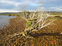
Mangroves and stony foreshore

View across Spencer Gulf to the Flinders Ranges
 
Fitzgerald Bay
Mon. Jan 24th
Busy doing nothing in Fitzgerald Bay! A good place to walk, try fishing and just enjoy the view. We did move campsites as we found the 2nd one, with toilets and water and a sandy beach in front. The Freycinet Walking Trail begins in this area and goes up and over the lighthouse at the southern tip of the bay – about 8km – and might be a good idea for tomorrow as we head out to Whyalla.

Thursday, January 20, 2011

Point Turton to Moonta - Yorke Peninsula wind-blown adventure cont.

Point Turton to Innes National Park
Thursday, Jan 20th
Hot strong north westerly wind meant that again we were looking for a wind break so hoping that the recommended Pondalowie Bay camp site would provide this.
The Innes NP has spectacular coastal scenery, with rugged cliffs, islands in close proximity and the beautiful blue waters of the Southern Ocean. The Chinaman’s Hat beach at low tide was perfect ...
Did I mention the wind?

and the Stenhouse Bay jetty was very scenic too.
We explored the old town of Inneston, which existed until the 1930s and the site was for the manufacture of plaster. The remnants were well signed, the salt lake incredible, although we later saw others that were more impressive, and it was a good spot to stop until the heat drove us back into the air-conditioned van.
The Pondalowie By site did not have shade but we found a spot out of the prevailing wind and set up for the day. The main bay had green fishing shacks in the sand dunes – strange in a NP but these had been there from the 1950s and the bay provides a very sheltered spot for mooring fishing boats, so the fishing rights continue. We walked to the bay then around the rocks to look across the spectacular view to the 4 islands that protect it from the open waters.


The next 2 bays were pretty and there were people snorkelling in Groper Bay so after a quick swim I decided to return and join them before the tide rose. As I was walking back along the road, a young emu came out of the bushes ahead of me, then another 3 of the same size joined it. Suddenly, a BIG male came out onto the road, stared at me and then gathered up the children to walk up the road. I followed meekly behind, hoping that my presence was not going to cause him to confront me! All ended well when he took them off into the bushes again. That evening we had a mother kangaroo and a joey feeding just metres from us. We also had bush flies and march flies in plague proportions. A small price to pay for such a beautiful part of the country, but Graeme has vowed to push on!
Pondalowie Bay to Moonta
Friday, Jan 21
A strong change of wind direction had us up in the night, pulling in the awning before it blew away. At first light I was up to go for a walk to the lighthouse while GVS packed up the van, ready to move on to a spot out of the wind where he could go fishing ..... not sure if there is such a spot on the Yorke Peninsula. We drove for much of the morning, following the tourist guide and the Camps 5 guide but the wind kept us on the move. Finally, in mid-afternoon, we came to the historic and very well presented town of Moonta, now a major holiday destination for Sth Australians, on the shores of the Spencer Gulf. We felt at home here in the obviously affluent tourist town and booked into the caravan park for a couple of nights so that we could once again have a drive-free day. The most expensive rate yet, at $34 a night, but a very beautiful bay where the tide went out to the same degree as it does at Rosebud. The water was bath temperature and the pier was bigger and better than any of the others!! GVS thought that he might try flounder fishing at night if the now-calmer wind abated. I’ll wait and see as he also bought fresh whiting and wine for dinner so I don’t think he’ll make it.
I’m not sure about this purposeless nomadic life with just 2. For the first few weeks it was an adventure; there were lots of adjustments to be made but it was fun trying out new things in the van and new places along the way. However, the itinerant and isolated lifestyle doesn’t seem to be the life for me. The sooner we settle in one place and I can find some work – voluntary or paid – the better I will be. Perhpas it's time to put some of that ESL training to use.

Moonta Bay – the home of the sand crabbers!
Sat. Jan 22nd
Beautiful, hot day with sea ‘breeze’ – not as windy as other days but grateful for the wind across the water in the afternoon to keep us cool. Too hot to go to town in the afternoon. Pretty bay with incredible tidal movement across the whole bay ...... long walk to the water for a swim at low tide! Even the 'shark-proof' netted off swimming area alongside the pier was in the shallows. The pier was busy early, with lots of crab pots as well as fishing lines. This is a crabbing centre, along with other parts of the Yorke Pen.

Tuesday, January 18, 2011

Bound for South Australia

Menindee Lakes to Burra Creek Gorge Sun. 16th Jan
We woke early to a scenic view across the water – a room with a view! Last night’s mozzies convinced us of the need to be on the move again, so we set off to Broken Hill, passing egrets feeding in pools of roadside water, little corellas eating the paddy melon seeds and emus galore.
On through Broken Hill and into South Australia, almost immediately noticing the changing landscape from well covered green land to much more sparsely vegetated, drier expanses. As we travelled south we began to see dry, treeless ranges misted in a heat haze. Huge distances with little change, then we took a turn off to Terowie as it was signed as an historic town. Terowie – wowie! It was once a changing post between the 2 different gauges of rail line, a prosperous region because of the need to change passengers and stock over to different trains. Douglas Macarthur and his family stopped there during WW2 on his way from Darwin to the southern capitals. Now the population is tiny, the stone and brick houses and shops are still there but empty and it won’t be long before the town dies completely. An entertaining older couple volunteered their time to run the museum but volunteers for other sites are not around.
From Terowie we travelled across vast wheat-growing plains where the harvest was still taking place and there was certainly ‘sun on the stubble’ – more about Colin Thiele later!  The extent of these paddocks was amazing and the huge machinery needed to harvest and store the grain travelled the road with us. We later discovered that the deserted farmhouses in these paddocks were there because the multinationals bought the smaller farm holdings and merged them and they had no need for the housing. Who owns the food that we grow?
We continued on to the beautiful tourist town of Burra, where the art gallery is home to a number of T S Gill paintings that he was commissioned to paint in the mid 1800s. The copper mine there, established in 1845, just 9 years after the colony of free settlers was founded, was the largest in Australia and reportedly saved the fledgling SA colony from bankruptcy.  Continuing on towards the coast, we again commented on the endless wheat paddocks, the deserted houses.
We had decided to spend the night at the Burra Creek Gorge but we were amused when we arrived to find a lovely, very large camping and picnic area set next to a dry creek bed and no gorge in sight. Terminology is a wonderful thing! We found a couple of pools and set up camp, ensuring that we were not under any branches as the eucalypts there were enormous – girth around 8metres and at least 20 metres high – and most of them showed clear evidence of having dropped limbs frequently. A quiet drink beside the billabong, watching bees coming in to drink, dragonflies hovering and swarms of small insects hovering over the water. Perfect!
Burra Creek Gorge to Point Turton on the Yorke Peninsula.
Mon. Jan 17th
Kookaburras sang of the approaching dawn, then the dawn chorus began in earnest. A lovely sunrise began our day but it became cloudy as we approached the coast. Our first stop was the information signs at Robertstown, where we learned about the ‘Goyder Line of Rainfall’. Goyder travelled widely on horseback through the SA colony and advised the government of the line beyond which settlement was unlikely to be sustained due to low rainfall. Needless to say, pressure from settlers, business and pastoralists won out and the resultant problems when people were forced to walk off their farms were faced again and again over the next century.
Wheat and a little merino wool keep this area going now and we travelled on to Eudunda, the birthplace of Colin Thiele, one of the first Australian children’s authors that I recall reading as a primary school girl and beyond. His memorial statue shows him with Mr Percival. From there we noted the large number of wind turbines set on each and every hill. Without water or coal, the SA government must look to alternative energy sources.
We arrived at the coast, enjoyed lunch overlooking the tidal flats at the tiny town of Port Wakefield, then we headed towards Androssan on the Yorke Peninsula. It was very windy and Graeme was regretting our decision to leave the Flinders Ranges for a cooler time of year. We headed from the east to the west coast of the peninsula in search of a sheltered place to spend the night. Barley is the crop here and harvesting was in full swing. Huge grain silos on the east coast and a port there to take it away by ship. Looking for a sheltered bay, we headed for Point Turton with baited breath as we were tired and didn’t want to drive any further. It turned out to be a great choice as it was sheltered from the southerlies and our site overlooked the Spencer Gulf and the coastline of this part of the Yorke Peninsula. A large pier was covered in fishermen, women and children, the water was turquoise over the sand flats and crystal clear. We soon decided that a couple of night here would not be too difficult for us to take!
Point Turton
Tues. Jan 18 and Wed. Jan 19
As we were settling into one place for a few days, it was time to take the bikes off the rack, dust them down and set off for a ride around town.  We found the store and it was run by a man who baked his own bread and pastries. Graeme was keen to try the fresh bread so we planned our day around eating our present supplies to make ready to tomorrow’s gastronomic delights.
On this perfect summer day with a temperature of around 25, a gentle cooling breeze of about 14 knots (perfect for sailing), Graeme frightened a large seal when he clambered  across the rocks at the base of the cliff to find the perfect fishing spot and came face-to-face with it. I wonder who had the biggest fright!
 I went for a long walk along the gravel walking track and waded in the warm shallows of the bay. The sand on the beaches was saturated and I sank into it – no fine white dry sand here – however it was great to have the opportunity for an extended walk. When I returned to the rocks to find Graeme, the seal was swimming directly in front of us, rolling first one way and then the other, scratching its face with its flippers and seemingly just relaxing in the water. Snorkelers just 10 metres off the shore had a great view of it. The afternoon was whiled away out of the sun, just relaxing and enjoying a day without driving anywhere. 

Dinner at the Turton Tavern was a treat. The food was as good as we have eaten anywhere and accompanied by a glass of delightful Clare Valley Riesling. The serving size was very large so we needed to walk after dinner and we discovered that Point Turton extended around the point and is a widely spread community in which most houses have beach frontage.

Broken Hill, Silverton, Menindee Lakes and back

Broken Hill
Friday, Jan 14th
The Miners’ Memorial loomed large and the ‘mountain’ of tailings ensured that we all knew that this was a mining company town, in the past if not so much in the present. In the 1950s and 60s, if you did not do a shift in the mine then you could not live there. However, as the memorial clearly indicates, the work was dangerous and killed many, mainly through accidents and lead poisoning.  Destruction of vegetation around the town for use in the mines and smelters increased the severity of natural dust storms, and smelters and mine plant belched noxious fumes and dust over the town. There is no sign of this now, although there is only one mine working now and production is small.
Street names are interesting as they are named after locally significant individuals and minerals such as chloride, argent etc. Mornington has a water-themed street called SprayJ
Source: http://www.brokenhill.nsw.gov.au/about/1002/1011.html
It was time for some ‘time out’, so Graeme went to the art galleries and I visited the Minerals Museum which gave an excellent insight into the formation of the minerals in the area as well as holding The Silver Tree, an amazing silver table centrepiece showing a boundary rider, Aboriginal men, Australian animals etc.
The city centre was well set up for tourists, with many signs offering information about the beautiful buildings and their history ... sandbags in doorways were indicative of the rain of the past few days. Wide streets, wide verandahs and a generally exceptionally well-maintained CBD. The regional art gallery was set up in an ex-hardware store of massive proportions and magnificence. The gallery’s collection was small but consisted of some European art, early Australian pieces, Pro Hart and Hugh Schultz and, thanks to Pro Hart’s generosity, a Clifford Possum and a couple of Emily Kngwarreye works.
The later part of the afternoon was spent travelling the road to Silverton – 39 dips indicated why it was closed after the rains ... water still on the roads in certain parts but passable. This provided us with another chance to see flooding in the outback. Silverton was fascinating. Once a prosperous mining town, the boom in Broken Hill saw its demise and many of the buildings were relocated to The Silver City, leaving only a skeleton town, hence its appeal as the town at the end of the earth in Mad Max and other movies. Mad Max relics everywhere and another film to be shot just as soon as the place dries out and the green vegetation disappears into the red dust.
From Silverton we headed back into town to the Pro Hart Gallery where I became even more aware of the man’s ability to cash in on his popularity. It seems that he painted around 100,000 paintings in his lifetime! I do not appreciate the 70s and 80s racetrack works with their caricatures of local race meetings, but his works on the mines and miners I enjoyed, especially his cubist works.
Back for a swim in the pool, dinner and, as Mad Max was not in our DVD pack, the Pirates of the Caribbean saw the night out.

Broken Hill to Menindee Lakes
Sat. Jan15th
We set off on the 110km drive over gently rolling green hills and plains to Menindee and finally saw some wildlife – a flock of about 30 emus and later, family groups of 3 or 4. We even saw our 1st kangaroo! The township was well kept. Although the caravan park on the Darling River had been evacuated and was flooded. Not much time to get out, I suspect, as vans were just left and there was even washing on a line.
This information from http://www.menindeelakes.com/history.htm explains the history of the area.
Major Mitchell discovered the area around Menindee in 1835 and it was to become a major depot for later explorers, a jumping off place for the interior. The lakes were seasonal but significant. Charles Sturt travelled up the Darling from the Murray and arrived at the site of Menindee in 1844, during his exploration of the interior.   Pastoralists, drovers and shepherds followed in the wake of the explorers. Captain Francis Cadell, who pioneered the operation of paddle steamers along the Murray, established a store near the hotel at Menindee in 1856. Settlers began to pour into the region with news that the Darling was navigable.
www.kidcyber.com.au states: In 1860 the Government of South Australia offered a prize to the first expedition to cross the Australian continent from south to north. Policeman, Robert O'Hara Burke led an expedition which left from Royal Park, Melbourne on 20 August 1860.
Burke travelled with 18 people, 25 camels, 22 horses and some wagons. This was the first expedition to use camels as a means of transport. Burke took a 2 year supply of food, as well as 80 pairs of shoes, beds, hats and buckets, as well as some firewood.
The expedition reached Menindee in about 8 weeks. It is believed that while here, Burke heard that Stuart was going to attempt to cross the continent from south to north also. Burke left some of the men there and went on with others to Cooper Creek where he established a base camp.
Burke's plan was to wait at Cooper Creek until the others arrived. But five weeks passed and they did not arrive. First they were delayed back at Menindee and then on the journey to Cooper Creek some men got sick and died.

The lakes region consists of four large natural lakes, Wetherell, Pamamaroo, Menindee and Cawndilla and several smaller interconnecting lakes a series of weirs and channels, and creates a water storage area and playground for Broken Hill Speedboat Club. The lakes also allow for storage of the Darling River water for irrigation and farming purposes lower down in the Murray/Darling basin, however, as the lakes are full from the rains in Queensland in December and are expecting more water from the recent QLD floods, the areas below the lakes are likely to have some major water issues later in February. What a stark contrast to the past 20 or so years of drought and the demise of so much bird and plant life.

Roads into Lake Menindee roads were closed so we walked to the edge, observing cormorants and, surprisingly, silver gulls! Whether the brown water is usual or the effect of recent downpours, I do not know.  We checked into the van park at Copi Hollows and set up on the lush green grass next to the water and spent the day reading, fishing and relaxing in the shade.  A couple of kangaroos came to the lake edge to feed at dusk, large lizards roamed, mozzies swarmed and a herd of feral camels came to the camp fence. The families from the speedboat club enjoyed their country and western music and Johnny Cash was king of the airways! A beautiful sunset, evening temperature around 30 in the van but cooler outside with the gentle breeze over the water.  Frogs, cicadas, galahs and kids!

Capertee ... yes, I know ... WHERE???.... to Nyngan and beyond, not as we planned!

Capertee to Nyngan
Wed. 12th Jan
A fascinating day’s travelling. We woke to morning misty showers after spending the night at a roadside stop, with the passing of trucks through the night. We decided that the weather limited sightseeing at the NP so we plan to revisit on our trip down the eastern side of the country in Nov. or Dec.  On, then, to Mudgee and beyond! Mudgee was a prosperous town set in a wine growing and agricultural region. The 1870s buildings have been well maintained and the wide streets are very attractive.
The beautiful Mudgee Railway Station

Henry Lawson's birthplace


Tourist information was excellent and we enjoyed wandering the streets with our historical building map. The enormous gothic-style Catholic church was indicative of the wealth of the early pastoralists and then the gold boom, although Henry Lawson’s works show the other side of the picture! Lawson’s birthplace was nearby but just a chimney left, however the Lawson museum at Gulgong was excellent and the whole town was still reminiscent of a gold town in many ways, with some streetscape preservation and narrow streets, worth a visit but a struggling town, I think.
We travelled on to Dubbo while listening to ‘The Loaded Dog’ and laughing at wry humour of the tale. Dubbo still bore evidence of a major flooding of the Macquarie River in December. Another big, well-maintained country centre. We didn’t visit the old gaol and apart from the Plains Zoo there wasn’t much for us, so on the road again as we were keen to head to the wild west! Out along flat, open roads – a complete change from the winding, hilly, narrow roads that we’d been travelling. Sheep and wheat country from Dubbo until we reached Nyngan where we stayed our first night in a caravan park. Yes, that shower was wonderful – our first since Canberra!
Nyngan is at the edge of the Outback and on the Barrier Highway to Broken Hill . A small town on the banks of the Bogan River, and explorer Thomas Mitchell camped at the site of the present-day town in 1835.  The Bogan River was up to the top of its banks and the water skiers were having a great time – this made fishing tricky! Mozzies drove us inside after dark.
 

Nyngan to Cobar and on to Wilcannia then beyond – wonderful and terrible
Thurs. Jan 13th Happy Birthday Brydie
Awoke with the birds before 6 and settled down by the river to enjoy the sunrise and the early morning light and breeze. A hot, cloudy and windy day ahead with rain forecast.  Graeme tried to catch breakfast but just fed the fish.
We hit the road before 9! A record for us! And what a road ................... beauty of a different kind. Initially long flat plains with native cyprus pine and grey/green casuarinas and low shrubs set in saltbush and swirling light green grasses that gave way to open plains with fewer trees. At times there seemed to be an invisible border that designated immediate change in the vegetation – fascinating.
Cobar - pastoralists moved into the area in the mid-1860s and it was in 1870 that copper was discovered and the town sprang up. Cobar is a mining town, one of those deceptive country towns which can easily be driven through, but the superb Cobar Heritage Centre, the old open cut mines, and the homes and public buildings off the main road make it well worth a stop. It was obviously a wealthy town and one of the pubs has a verahdah over 100m long!
 The heritage centre was set in the copper mine’s Victorian administrative offices contained a wonderful display of the history of the area, copper mining and early life in the outback.  There was a train carriage that was used by the maternal health sister in the 1930s – reminded me of the wonderful book about a train that travelled through the Mallee - Everyman's Rules for Scientific Living.  


An interesting story about the naming of the town states that 'gubar', the Aboriginal word for red ochre, was simply corrupted to the Anglicised 'Cobar' when an old man was sitting down, making paint for corroboree. He was painting himself when a whitefellow came riding and asked what he was doing. 'I'm making paint for corroboree.’ He showed him the gubar, the red ochre. That's how they named Cobar. The old man showed him where it was, and it was copper worth thousands of pounds.
By 1871 the townsite had been surveyed and by 1876 the main mines had amalgamated to form the Great Cobar Copper Mining Company. The mines continued to operate until 1920. At its peak Cobar Pastoralists moved into the area in the mid-1860s and it was in 1870 that copper was discovered and the town of Cobar sprung up. The town and the surrounding villages and camp sites had a population of over 10 000 people. It was so prosperous that it even had its own stock exchange.
Cobar's population dropped to a little over 1000 during the 1930s and rose again to stabilise at around 3500 through the 1970s and early 1980s. However the opening of a silver-lead-zinc mine in the early 1980s gave the town a boost so that now the population is about 5300.
The CSA Mine (the letters stand for Cornish, Scottish and Australian) is now New South Wales' largest producer of copper and zinc.
Source- Sydney Morning Herald, Jan 11, 2011. http://www.smh.com.au/travel/travel-factsheet/cobar-20081113-5ypi.html
 Unfortunately heavy overnight rain in the Wilcannia and Broken Hill areas meant that many of the dry-weather roads were closed, including those to some of the National parks and Mount Grenfell, which has some of the finest examples of rock art in Australia - three main rock shelters with over 1300 richly coloured images including human and animal figures and hand stencils.  Next time, perhaps.
So, we continued on to Wilcannia, where we had planned to spend the night, but nothing prepared us for the ghost town that we found! Wilcannia is situated on the banks of the Darling River, which was running to the top of its banks. The main street of Wilcannia is lined with historic sandstone buildings – a superb police station, courthouse and others but every other building seemed to be boarded up or covered in iron bars. The only people we saw were a few Aboriginal people sitting, chatting, and a white barmaid helping an Aboriginal man by carrying a box of beer to his car. Oh, we did try to visit the Pioneer Museum but, despite the sign, the very abrupt woman at the government office told us it had closed down years ago! Like the town. Yet, once upon a time, Wilcannia was known as the "Queen City of the West “and it was the third largest shipping port in Australia. In the boom years of the 1880's sandstone was quarried locally for the beautiful buildings that stand today as a reminder of those days when the river was king.
Needless to say, we didn’t stay but decided to drive on despite the looming grey rain clouds .. and rain it did! The endless flat, treeless plains towards Broken Hill were green, indicative of earlier rain. In fact we later found out that Broken Hill had experienced over 150mm of rain in the past 3 days when the average annual rainfall is about 240mm. We passed flooded plains, orange creeks that carved red gorges in the desert, water slipping over the road and were thankful that we made it through to Broken Hill as this road, and the roads to Menindee Lakes, Silverton and Adelaide were later closed due to flooding.
A quick drive through Broken Hill indicated that we could easily spend time in this attractive and interesting town.

Canberra, Katoomba, Windsor and the west

Canberra to Darbys Falls near Cowra
Sunday, Jan 9th
We set off just before lunch and headed up the Barton Hwy to Yass. A lovely old town with a great little museum where the drawn images of the old town are shown below photos of the same sites in the 1990s. This seems a clever way of displaying past and present, particularly as artefacts relating the building use were displayed below the pictures.
From Yass we headed north-west to Boorowa where the purchase of cherries removed the necessity to drive to Young! A cup of tea on the riverbank gave us a chance to appreciate the level of flooding that had occurred in this region as the debris was caught in the trees metres above the present river level. As we headed on towards Cowra we could see the storm happening along the ridges and in the valleys ahead, with fork lightning and loud claps of thunder coming with torrential rain – a very tropical storm as we were still in shorts and t-shirts. At one point we stopped on the roadside and waited for the storm to pass. As a result, we decided not to stop in Cowra, particularly as most of the points of interest were new, but the information about the biggest prisoner of war escape in modern warfare is well worth reading. We drove on to Darbys Falls campsite beside the Lachlan River where we were astounded to see the picnic tables and seats covered in mud – the river here had risen over 9 metres! Hard to envisage. Even the toilets were covered in mud. We spent the night there, with thousands of cockatoos coming in to roost in the trees, the carp in the river taking Graeme’s worms and the cicadas noisily settling in for the evening too. We were the only ones there over night and woke to the raucous screeching of the cockatoos and a warm wind.

Huge branches carried by the flood waters


Flood debris high in the trees


Clean creek water flowing into the muddy Lachlan River
 
Darby’s Falls – Flat Rock near O’Connell
Mon. Jan. 10th
Carp, cicadas and a cacophony of cockatoos! Wonderful soundscape! We drove on through rocky but very green hills .. no sunburnt country in sight, and came to the beautifully preserved and restored village of Carcoar, a very special place. The first buildings dated to 1836, the year that the colony of SA was being established and one year after Melbourne was founded. The surrounding countryside of magnificent hills and valleys made good sheep country however the discovery of gold in the 1860s in this region, which includes Bathurst, is evident in the magnificent churches and civic buildings from the boom years. Wind farms on the hills indicate the local weather conditions!


We visited nearby Millhurst, another beautifully preserved gold rush town before heading into mighty Bathurst with its huge buildings and streets that reflect its days as the centre of the area’s economy. Bathurst was much larger than we had expected and the buildings from the early days were certainly built on a grand scale. As we are determined to keep off the main roads and out of the large towns as much as possible, we did our shopping and headed out to the Fish River camping site at Flat Rock. A magnificent spot with a fast running river and, of course, a large flat rock!

As it was very windy weather and overcast, it was time to put on a jumper for the 1st time. A few fellow campers and some day-tripping fishermen but very quiet once again.  Some phone calls to home, before we moved out of range, indicated that the rain was still pouring down in Queensland and Toowoomba and Brisbane were in real trouble. Stu assured us that he was safe in Brisbane but that the office was not. As a result, we decided that our trip should continue in a westerly direction after we have been in the Blue Mountains, Richmond and Windsor.

Flat Rock to Windsor and back again ... the best laid plans J
Tues. 11th Jan
Misty Blue Mountains, Windsor, misty Blue Mountains and Lithgow and beyond – not that we saw anything! Set off feeling non-too-comfortable about the weather. We arrived in Katoomba in rain and grey mist and we left an hour later in worse conditions! Not a sight to be seen. On to NSW Roads Dept.‘s constant road disruptions but for little immediate outcome! Most country roads are in poor condition while the city roads are being constantly closed or limited for roadworks!
We went as far east as Windsor and enjoyed walking around the historical buildings in this Lachlan Macquarie and Francis Greenway village on the Hawkesbury, however the inclement weather and news reports about the QLD and NSW floods led us to head back over the mountains and on to a little roadside stop at Capertee, just out of Lithgow. Heading north is not an option, so it’s westward ho!