Onwards from Moonta Bay
Sun. Jan 23rd
A big day of travelling despite our resolution to keep these legs of our trip short – save up the energy for the Nullarbor crossing!
We left Moonta and headed north up the coast, constantly amazing at the incredible tide movements. Huge tides means huge jetties and piers at each of the coastal towns. Port Germein was too long to walk in the afternoon sun!
Port Pirie - the first sight was the huge oil tanks on the outskirts of town and the grain silos and the chimney at the smelter, however it was an interesting place. The local aboriginal people are the local Nuguna people and the area was first explored by Matthew Flinders who came up the Spencer Gulf in 1802. According to the SMH fact sheet, http://www.smh.com.au/travel/travel-factsheet/port-pirie--culture-and-history-20081119-6bbu.html, the critical event in the town's history was the construction of the smelting works in 1889. This ensured the town's continuing future. It was greatly compounded by the completion of the Broken Hill Associated Smelters Pty Ltd smelting works in 1915. By 1934 it was the largest single-unit lead-smelting works in the world.We enjoyed the museum with its eclectic range of items of some historical interest. The building was superb – the old station certainly had an aura of wealth. Port Pirie has a lead smelter, set up originally by BHP to process ore from Iron Knob. It has a large port set on the river and a town with incredibly wide streets as the train once ran along the centre of the main street.
We visited the Tourist Info Centre and adjoining art gallery where the ‘grey brigade’ had an exhibition which was interesting. One of the painters had stunningly good portraits of a range of people in shearing sheds, including an Australian/Maori shearer, Aboriginal jackeroos and other workers. His portrayal of faces was wonderful to see. A sculptor had used scrap metal from around the area to create some amusing and some clever pieces.
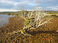
We visited the Telowie Gorge, a small but impressive gully through the red cliffs of the lower Flinders Ranges but Germein Gorge was very disappointing. We drove to Mt Remarkable camping ground, planning to spend the night and a couple of days there, but decided that we needed water – I must have Aquarian connections! As a result, we kept driving through Port Augusta and on to the most beautiful free camp site at Fitzgerald Bay on the Eyre Peninsula. The view across the mangroves to the Flinders Ranges on the other side of the Spencer Gulf was stunning; a breeze was blowing and there were fishing boats and kingfish farms in the southern part of the bay and once again we had a ‘room with a view’. The area is of geological interest as the small rocks here have formed the equivalent of sand dunes and the mangroves grow in this stony environment.
 |
| Sunrise on Fitzgerald Bay |
 |
| Mangroves and stony foreshore |
 |
| View across Spencer Gulf to the Flinders Ranges |
Fitzgerald Bay
Mon. Jan 24th
Busy doing nothing in Fitzgerald Bay! A good place to walk, try fishing and just enjoy the view. We did move campsites as we found the 2nd one, with toilets and water and a sandy beach in front. The Freycinet Walking Trail begins in this area and goes up and over the lighthouse at the southern tip of the bay – about 8km – and might be a good idea for tomorrow as we head out to Whyalla.
No comments:
Post a Comment